New Jersey Butterfly Club
A chapter of the North American Butterfly Association (NABA)
Walpack Area (Delaware Water Gap NRA & Stokes SF)
by Tom Halliwell
County: Sussex.
Municipality: Walpack Township.
Directions: Take Route 206 north past Culvers Lake and turn left onto Struble Road (DeLorme 18: J-12). This hard-to-see turn is a few tenths of a mile north of the turnoff to Stokes Forest HQ or about a mile south of the turnoff leading to Layton (Route 560). Take this road for about 5–6 miles to the church in Walpack Center and park across the street. Along the way you will have passed Tillman Ravine and Walpack Cemetery, and crossed the iron bridge over the Flat Brook.
Parking: Yes. In addition to the area across from the Walpack church there are several other access points with parking, and it’s OK to pull off along roads with sufficiently wide shoulders. Use common sense. See below under “Exploring....” Investigating the area’s roads will no doubt yield additional stops with excellent butterflying.
Nearest sizable town: None. Gas and food are available on Route 206 in the Culvers Lake area. The small town of Layton is about 5 miles north of Walpack on Rt. 560 and has a few services.
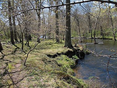
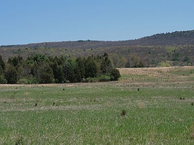
Habitats: Numerous old fields, most with Little Bluestem grass. Also there are extensive areas of deciduous forest, Eastern Redcedar woods and openings, and Hemlock-hardwoods forest (at Tillman Ravine). A beautiful, wooded riparian corridor borders the Flat Brook all through the area. The scenery in this area simply cannot be beat.
Maintained/Marked trails: Many, though most are in forested areas. Most butterflying is along dirt roads and in the many fields.
Restrooms: Yes. There is restroom at the Stokes SF HQ on Rt. 206 just north of Culvers Lake. A portable toilet is available at the Walpack church, and there are pit toilets at the two parking lots for Tillman Ravine, which you pass when descending the hill toward Walpack.
Picnic tables: No. Groups often find shady lunch spots near the parking areas of the Walpack Cemetery and the Roy Bridge (see “Exploring...”).
Notable species: American Copper, Harvester (rare), Eastern Pine Elfin, Juniper Hairstreak, Aphrodite Fritillary (rare), Meadow Fritillary, Baltimore Checkerspot (rare), Compton Tortoiseshell (rare), Hackberry and Tawny Emperors, Northern Pearly-eye, Red-spotted Purple, White Admiral (rare), and Cobweb (rare in spring), Leonard’s (rare in late summer), Crossline, and Delaware Skippers.
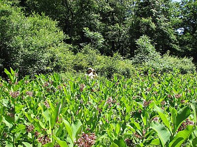
Best time to visit: Anytime from April to September, but the (mid-June to mid-August) peaks of bloom for Common Milkweed and Wild Bergamot are the most rewarding.
Exploring Walpack Area: From the parking area opposite the Walpack church walk back down the hill and immediately after crossing the iron bridge take the trail on the right, which parallels the Flat Brook. Walk along the trail and into the fields. A good mix of butterflies can be found here such as Juvenal’s Duskywing, Viceroy, Common Ringlet, Great Spangled Fritillary, and American Lady, as well as the common swallowtails and sulphurs. American Copper can be very common in the second field along the Flat Brook. Wildflower enthusiasts should be sure to walk on the floodplain near the Flat Brook, especially in spring.
Return to your car. Drive back down over the iron bridge and go a few tenths of a mile to the intersection with Mountain Road (dirt). Turn right and park along the right edge of the road next to the Walpack Cemetery railing (or pull into the rough parking spot on the left at the end of the cemetery). Butterflying can be excellent just walking along Mountain Road and poking into adjacent fields for about a half-mile in either direction from the intersection. Along the road, especially in damp areas, one can find Red-spotted Purple (occasionally in triple digits), Northern Pearly-Eye (in wooded sections), Eastern Pine Elfin (in spring on roadside Cypress Spurge), Hackberry and Tawny Emperors, Eastern Comma, and Question Mark, plus the occasional Compton Tortoiseshell and “White” Admiral. To access an interesting Red-Cedar–Little Bluestem opening walk north from the intersection on the dirt road (away from the cemetery) for about 100–200 yards. Before the road emerges from the woods turn to the right and bushwhack up the hill for another 100 yards until you reach the dense Red-Cedars. Look for the large opening, which is bounded by a small cliff on the left (north). The opening is slowly getting smaller due to succession by Red Cedars, but is still worth the hike. Wildflowers can be spectacular here with Moss Phlox, Wild Columbine, Early Saxifrage, and others offering excellent photographic possibilities in early spring. Work the opening from the cliff around to the right looking for American Copper, Eastern Pine Elfin (spring), Juniper Hairstreak, Cobweb Skipper (rare in mid-late May), and Leonard’s Skipper (rare in mid-late August). Returning down to Mountain Road, continue to the right (away from the intersection). The big field on the left has been good in the past for numerous grass-skippers, including Crossline and Tawny-edged, as well as Meadow Fritillary and Viceroy, among others. In recent years it has become overgrown with invasive shrubs and is difficult to traverse. It is worth checking, though, as it is always possible that the Park Service may brush-hog the field to improve accessibility.
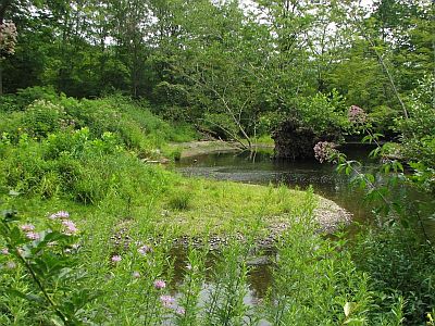
An excellent place for seeing butterflies in this area is the Roy Tract. Drive back through Walpack Center to the T with CR 615 (Walpack-Flatbrook Road). Turn right, drive about 1.8 miles, and take the backward-slanting right turn. Park at the end of the road past the iron bridge (Roy Bridge). Walk back, cross the bridge, and walk a few tenths of a mile to the T intersection with Mountain Road. (This is the same road as before, but somewhat farther north.) Explore along Mountain Road for about 0.25 mile to the left and 0.5 mile to the right. The butterflying on or adjacent to these dirt roads can be wonderful. Meadow Fritillary can often be found in grassy areas near the T intersection or in the big fields on the right between the bridge and the T. These fields can harbor many butterflies, but occasionally there are no trails mowed and the bushwhacking can be difficult. Hackberry and Tawny Emperors are possible on any section of these dirt roads, and Northern Pearly-Eye is regular. Two uncommon-to-rare butterflies to look for on the roads are Harvester and Compton Tortoiseshell. Harvester has been found intermittently over several years. Most often it is seen near puddles within a tenth of a mile of the T intersection, although once or twice it has been seen between the bridge and the intersection. Compton Tortoiseshell has been found on the road in all sections, but again, not every year. Puddles are an attractor, but the butterflies will bask on dry sections of the roads as well.
The Walpack area has so much habitat that it cannot be overemphasized that additional good butterflying spots are waiting to be found. One suggestion would be to spend considerable time along the aforementioned Mountain Road, which runs for 9 or 10 miles north to south along the base of the Kittatinny Ridge. As a dirt road it attracts mineral-seeking butterflies and old fields border it along much of its length. For example, south of the cemetery Baltimore Checkerspot and Aphrodite Fritillary have been found in roadside areas. Who knows what you might find? And don’t miss the spectacular (for NJ) Buttermilk Falls along the way!
Some dirt roads found on maps, including sections of Mountain Road, are not always well-maintained. Folks with vehicles that do not have high clearance should be very careful or walk from parking areas. For the portion of the Walpack area that is in the Delaware Water Gap NRA it would be a good idea to view the National Park Service's Current Conditions page for any updates on road conditions and closures. Especially look at the sections labeled "Alerts" and "Temporary Area Closures in the Park".
Special precautions: Ticks can be common in the fields. In addition to insect repellent, rubber knee boots are helpful in warding off ticks. Boots also help to protect pants and legs from Multiflora Rose that is common in some fields. Black Bears are common but usually inoffensive. Be sure to lock your car and conceal any valuables. As on other federal and state lands, collecting of living organisms is prohibited without a permit.
You might also want to visit: Flatbrookville.
General information about Delaware Water Gap NRA is available.
General information about Stokes State Forest is available.
To view a larger map, click on 'View larger map' icon in upper right hand corner. (Tip: The satellite view may also suggest good potential butterfly habitat to explore.)

Riparian corridor along the Flat Brook just downstream of the iron bridge.

Field along the Flat Brook near iron bridge below Walpack church.

Butterflying a milkweed patch near the T intersection at Roy Bridge.

The Flat Brook near the Roy Bridge.