New Jersey Butterfly Club
A chapter of the North American Butterfly Association (NABA)
Passaic River County Park
by Mike Newlon
County: Morris.
Municipality: Chatham Township.
Directions: Note: Roads in this area often change names at municipal boundaries, and different roads may have the same name in adjacent municipalities: Bridge Avenue in Chatham Township becomes Snyder Avenue when it crosses the Passaic into Berkeley Heights, Union County; River Road in Chatham Township is not the same as River Road in Summit.
From Interstate 78: Take exit 40 and turn north on Hillcrest road (County Road 531). Go to a four-way stop sign (1 mile), cross Mountain Avenue, staying on Hillcrest Road (CR 531). [Hillcrest Road becomes Mountain Avenue after passing over the Passaic River Bridge]. In 0.7 mile, at the traffic light at County Road 512/Valley Road, turn right (Valley Road becomes Springfield Avenue once you enter Berkeley Heights); continue1.8 miles to the traffic light at Snyder Road. Turn left, cross the Passaic River into Chatham Township, Morris County (Snyder becomes Bridge Avenue). After 0.5 mile, at the T-intersection, turn right onto River Road. Go 0.6 mile to the park entrance on the right, marked by an inconspicuous sign. [Should the gate at this entrance be closed, continue 0.1 mile to Roosevelt Road, turn right, and continue to the end; walk across the athletic field to the parking lot. Note: the entrance road to the park is also marked Roosevelt Rd on Google Maps.]
From interstate 287 (southbound and northbound): At Exit 30 (Basking Ridge) go south on North Maple Avenue for 1.6 miles to the center of Basking Ridge; continue south (North Maple becomes South Maple) for 2.7 miles and bear left on Long Hill Road (becomes River Road); continue 4.6 miles to the park entrance on the right.
From Route 24: At Exit 7B take the John F. Kennedy Parkway south until it merges with River Road in Summit. Continue, staying to the right to remain on River Road, for about 1.1 miles. Bear right and cross the Passaic River into Chatham Township (River Road becomes Watchung Avenue). Turn left at the stoplight; this road is also called River Road. Continue 3.7 miles to the park entrance on the left.
Parking: Yes. Paved lot at the end of the entrance road (marked Roosevelt Ave on Google Maps). The Berkeley Heights section has parking at either end of the trail along the river.
Nearest sizable town: Berkeley Heights, just across the Passaic River; reached from River Road by turning south on Bridge Avenue/Snyder Avenue. On Springfield Avenue, which intersects Bridge/Snyder not far south of the Passaic, there are numerous restaurants and gas stations.
Habitats: River-bottom forest, Passaic River, powerline cut.
Maintained/Marked trails: No formal trails exist along the powerline cut. The Berkeley Heights section has a trail shown on this map.
Restrooms: Yes. There is a portable toilet at the parking lot.
Picnic tables: Two.
Species recorded: Eastern Tiger Swallowtail, Spicebush Swallowtail, Cabbage White, Clouded Sulphur, Orange Sulphur, Sleepy Orange (once), Gray Hairstreak, Red-banded Hairstreak, Eastern Tailed-Blue, Spring Azure, Summer Azure, Variegated Fritillary (rare), Great Spangled Fritillary (rare), Pearl Crescent, Eastern Comma (rare), American Lady, Painted Lady, Common Buckeye, Red-spotted Purple, Appalachian Brown, Little Wood-Satyr, Common Wood-Nymph (rare), Monarch, Silver-spotted Skipper, Horace’s Duskywing, Wild Indigo Duskywing, Least Skipper, Fiery Skipper, Peck’s Skipper, Tawny-edged Skipper, Northern Broken-Dash, Little Glassywing, Sachem, Delaware Skipper, Mulberry Wing (scarce), Hobomok Skipper, Zabulon Skipper, Broad-winged Skipper, Black Dash, Dun Skipper, Ocola Skipper (rare)..
Best time to visit: Mid-summer through early fall.
Exploring Passaic River County Park: Drive down the entrance road and bear left to the parking lot. The edges of the clearing here are usually worth checking. From the far end of the lot one can walk to the left of the pylon, then right and down a dike to reach the Passaic River. Then walk back up the entrance road to the right-angle bend. On the left, negotiate a short incline to the powerline cut. This can be walked all the way west to Bridge Avenue. It is possible to bushwhack through the woods on the left to reach the Passaic River. The powerline cut traverses open areas, wet swales, and stands of Phragmites reeds. At one place one must get over an often-flooded ditch; currently (2023) there is a narrow and wobbly plank bridge here. The track down the powerline cut is sometimes mowed but by late summer vegetation is often waist high. Note: by mid-afternoon the powerline cut can be in shadow and butterfly activity minimal.
Central Avenue Powerline Crossing, New Providence (Union County): This is another point of access to the powerline cut, good for butterflies in summer. Return to River Road, turn right, and continue 0.6 miles to Central Avenue. Turn right and proceed about 0.2 miles to the powerline cut, where there is space to park a few cars on each side of the road. The best butterflying is often close to the road, especially on the east side. In late summer look for a blooming patch of mint close to the road.
Passaic River Park, Berkeley Heights (Union County): Access to river-bottom forest, not much in the way of butterflies. Return to River Road, turn left, go 0.6 miles to Bridge Avenue, turn left. In 0.3 miles, immediately after you cross the Passaic River bridge, turn left into the tiny parking lot. Here a trail runs through forest along the river. Pileated woodpeckers and Wood ducks are seen here. Across the road from the parking lot, birders might try another trail which runs between the river and the Berkeley Heights Sewage Plant. In winter the sewage works may attract wintering passerines. The other end of the river trail can be reached by returning to Snyder Ave, turning left, and continuing about 0.2 mile to the intersection with Springfield Avenue; turn left and continue about 0.5 mile to the parking area on the left. Walk down the right side of the athletic field to reach the trail to the river.
Special precautions: The track down the powerline cut is rutted and after rains may be muddy or flooded; rubber boots are convenient and sometimes necessary. During summer mosquitoes and deerflies can be oppressive. Ticks are common and sometimes hyperabundant, so take appropriate precautions.
You might also want to visit: Great Swamp National Wildlife Refuge which is just to the north. Return to River Road, turn left, continue on River/Long Hill Road to Meyersville Road. Turn right, proceed to the Meyersville Circle, take New Vernon Road north to the Refuge.
Further information about the Chatham section is available.
Further information about the Berkeley Heights section is available.
To view a larger map, click on 'View larger map' icon in upper right hand corner. (Tip: The satellite view may also suggest good potential butterfly habitat to explore.)

Power Line Cut.

Passaic River CP Sign.
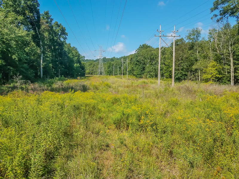
Passic River Powerline.