New Jersey Butterfly Club
A chapter of the North American Butterfly Association (NABA)
Colliers Mills WMA
by Greg Prelich
County: Ocean.
Municipality: Jackson Township.
Directions: To get to the main entrance, enter 40.06763, -74.44955 as the destination into your maps program; from Rte. 539 you will turn eastward onto E Colliers Mills Rd, and drive 0.9 miles to the entrance of the WMA, where Colliers Lake will be on your left and Turnmill Lake will be on your right. (See the map on this page).
Parking: Yes. There is a small paved parking area for six cars located beside Colliers Lake at the entrance. Colliers Mills is a large WMA of 12,906 acres, far too big to cover by foot alone; to explore it, drive further on the extensive dirt roads that traverse the WMA and park alongside the road anywhere that you find likely butterfly habitat. All of the WMA roads past Colliers Lake are wide sand/gravel/clay roads that are in decent shape.
Nearest sizable town: New Egypt is ~4.5 miles west of the entrance via W Colliers Mills Rd. Whiting is located 8 miles south of Colliers Mills via Rte 539.
Habitats: Colliers Mills is on the northern edge of the Pinelands, and as such contains extensive pine forest intermixed with mature stands of mostly oak. Abandoned cranberry bogs are present, with some near the roads, but many are difficult to access. A large grassy field greets you for the first half mile or so beyond Colliers Lake; this field and similar ones in this section of the WMA are interspersed with short breaks of oak forest (see the aerial map). These are not lovely flower-filled meadows full of color and butterflies, but instead are mostly grasses with sparse nectar sources; the fields are burned for maintenance purposes every year. Four lakes and a few roadside ponds/wetlands are accessible by car. A wide sandy power line right-of-way passes east-to-west across the WMA and alongside some fields, but it only approaches the dirt road system on the western side, so it is difficult to explore very far. At the eastern end of the WMA, Success Road passes through an American White Cedar bog just before reaching Rte 571.
Maintained/Marked trails: There are no maintained hiking trails. The extensive dirt road system (all the roads are unmarked) serves as a surrogate for hiking trails. The strategy here is to drive the roads, park where you find nectar sources or suitable habitat, and then explore that area on foot.
A good on-line map of Colliers Mills is available.
Restrooms: There are no rest rooms on site. It is best to stop in at gas stations before arriving at the WMA.
Picnic tables: There is no picnic area here. Bring a lunch and find a shady spot by any suitable roadside parking area.
Notable species: This is not a destination where many species will be seen or where butterflies are abundant, but it does contain several desired species, including Dotted Skipper, Bog Copper, Coral Hairstreak, Striped Hairstreak, and Oak Hairstreak, with a smattering of grass skippers such as Crossline and Tawny-edged.
Best time to visit: Most butterfliers visit Colliers in early June to mid-July when Dotted Skippers and the hoped-for hairstreaks can be found, along with a few other grass skippers. Look for patches of Orange Milkweed, Pine Barrens Sandwort, and Dogbane as the main butterfly draws here. In the wet areas, patches of cranberry serve as some of the northern-most locations in NJ that host a healthy population of Bog Coppers.
Exploring Colliers Mills WMA: Some directions and landmarks might prove useful for navigating through the WMA when combined with the maps that are included with this site description. Immediately after passing between the two lakes, the main unmarked dirt road that leads straight into the WMA is called Success Rd. A dirt road to the left parallels alongside Colliers Lake, leading to a dead end in about half a mile. A 300 yd walk beyond the dead end leads to a powerline cut.
Returning back to the entrance, Success Rd extends for 5.9 miles, passing though oak and pine forests; approximately 2.5 miles from the entrance the road forks. Taking the right fork leads to a brushy field beside Success Lake; after exploring here, head back to Success Rd and either go left to return back to the entrance, or go right, where the road passes the far end of Success Lake, eventually traversing through an American White Cedar bog before exiting at CR571.
Back at the entrance area, another unmarked clay road that goes right from the entrance sign (just before the lakes parking area) is Hawkin Rd, which extends for 0.9 miles along the western side of Turnmill Lake to a large sandy parking area at the far end of the lake (stay to the left when Hawkin Rd forks after 0.5 miles to reach this parking area). Trail options here are taking a narrow path along a smaller pond, or walk along the wide grassy dike that forms the dam of the lake.
The large fields interspersed with oaks make this a nice location to spot breeding Red-headed Woodpecker, Blue Grosbeak, American Kestrel, and Grasshopper Sparrows. You might occasionally spot birds such as Ring-necked Pheasants or Chukars that have been released and are lucky enough to escape the hunters.
Special precautions: The entrance fields of this WMA are often used by hunters for training their dogs. The WMA is also used by horse riders. Please respect each others interests. A police pistol range is located on the eastern side of Turnmill Lake that can result in disruptive noise but no danger, since access by the public is prohibited in that area. Hunting occurs in season; check annual regulations.
You might also want to visit: Crosswicks Creek Greenway and Assunpink WMA both of which are located in southern Monmouth County or Laurita Winery which is a 5 minute drive from the entrance.
To view a larger map, click on 'View larger map' icon in upper right hand corner. (Tip: The satellite view may also suggest good potential butterfly habitat to explore.)
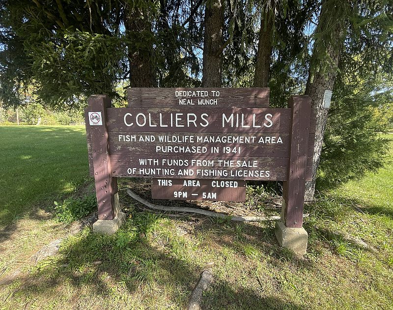
Welcome sign at the entrance to Colliers Mill WMA. The dirt road to the right of this sign when you enter is Hawkins Road.
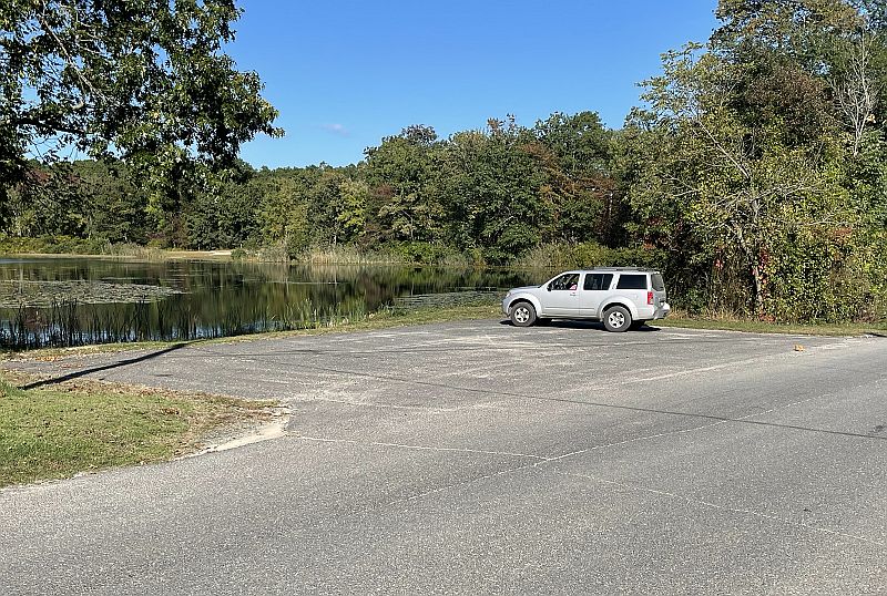
The parking lot at the entrance beside Colliers Lake can hold perhaps six cars, but parking can be done anywhere on the road system where there is room to pull off.
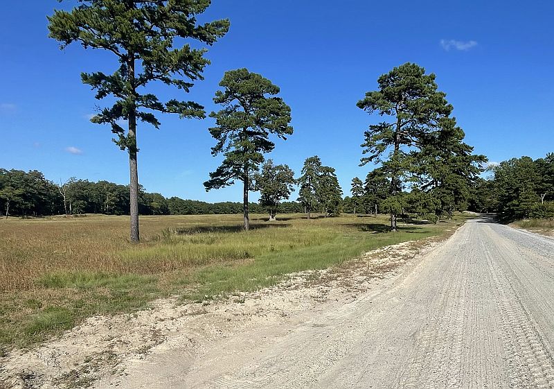
An example of the gravel/dirt roads within the WMA, as well as a typical grassy field. Look for nectar sources within fields like this.
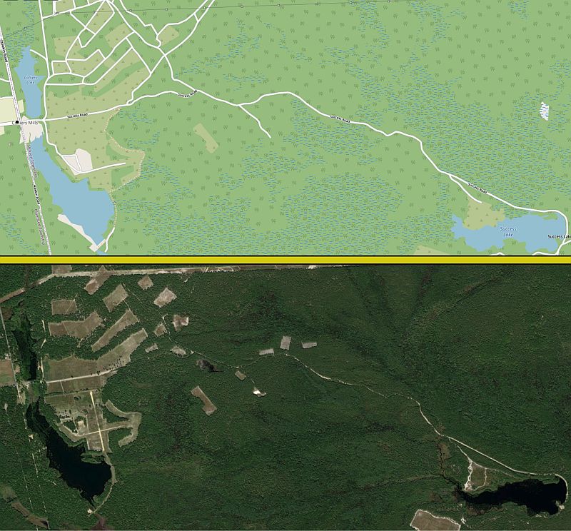
Two birds-eye views of Colliers Mills WMA, showing the main road (Success Road), leading from the entrance (on the left) toward Success Lake (on the right). The aerial photo in the bottom panel shows the fields and lakes well, while the top panel better displays the sandy paths (most of which are not driveable) that connect the large fields near the entrance.
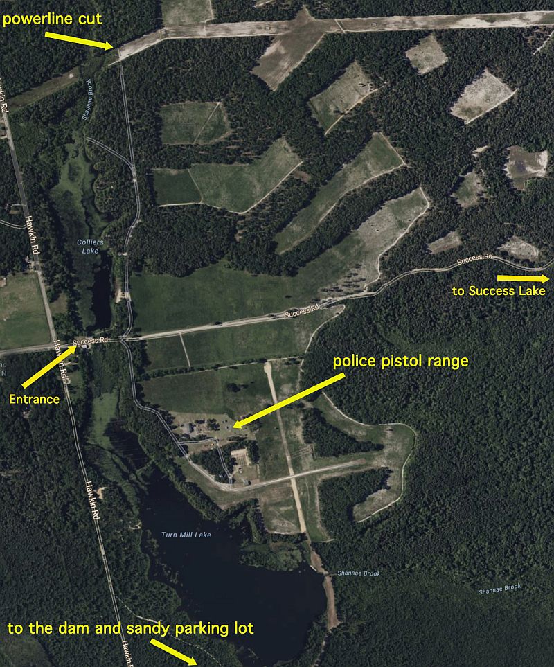
A closer aerial view of the entrance area of Colliers Mills. Success Road starts at the entrance and goes eastward (to the right), leading to Success Lake in ~ 2.5 miles. Multiple large grassy fields can been seen near this entrance area, including the wide powerline right-of-way near the top of the image. Rte 539 is 0.9 miles to the left (west) of the entrance.